Reverse Geocoding Resources
Learn more about reverse geocoding with open data
To be most useful, your reverse geocoder likely needs a lot of data. There are many sources for public domain data - as well as tools to make use of them. Using open data promotes accountability, transparency, and participation. It also gives you the most flexibility with how you can use your reverse geocoder.
Additional Resources for Learning about Reverse Geocoding
Throughout the guide we've discussed the basics of reverse geocoding and the various issues involved when building or buying a geocoding service. However, there is still much to learn. To further expand your geocoding and open data knowledge, here are some additional tools and resources:
- Learn OSM a great place to dive into OpenStreetMap
- The Open Data Institute (ODI) The definitive online resource for learning about the many benefits to open data.
Tutorials
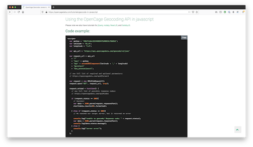
We offer
tutorials for using the OpenCage geocoding API
with cut and paste code examples
in over 40 different programming languages and frameworks.


Podcasts
The Mapscaping podcast, a popular podcast focusing on geospatial
technologies and trends,
interviewed OpenCage co-founder, Ed Freyfogle
.
Ed explains what geocoding is and many of the challenges in providing a
dependable geocoding API.
Ed also
chatted with the Iot for All's Let's Connect Podcast about geocoding,
particularly in the context of Internet of Things.
If podcasts about geo are your thing, you should subscribe to
the Geomob podcast,
which is co-hosted by Ed, and where we regularly interview guests from
across the industry.
Behind the API: Open Data Sources We Use at OpenCage
The
OpenCage Geocoding API
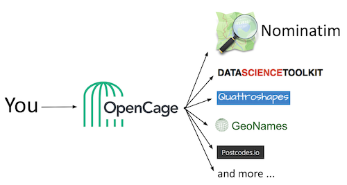
is the quickest way to get open data-powered reverse geocoding. We use many of the open data sources we highlight below. In addition, you'll find open source packages and developer utilities used in robust, scalable geocoding projects from within the community.


Nominatim and OpenStreetMap
As we've
discussed elsewhere in this guide,
OpenStreetMap
(OSM) is an incredibly important project, which drives a worldwide geo
dataset built by millions of individual mappers. OpenCage is a member
of the
OSM Foundation
and national OpenStreetMap chapters for the UK and Germany.
OpenStreetMap offers fantastic resources for map builders and other
geo-geeks.
Built by a community of mappers, OpenStreetMap's worldwide data is continuously updated. Anyone can use OpenStreetMap's always up-to-date data for any reason, as long as credit is given.
The most useful OSM project for reverse geocoding is
Nominatim.
DataScienceToolkit
DataScienceToolkit
is a collection of open data sets and open-source tools for data science. Wrapped in an easy-to-use REST/JSON API with command line, Python, and Javascript interfaces, DataScienceToolkit has ample data software pre-installed.
Flickr Shapefiles
The entire dataset of Flickr Shapefiles 1.0 is available as a single
download under
CC0 / Public Domain.
That's continents, countries, states, cities, and even neighborhoods.
Find interesting ways to use them yourself
here.
Geonames
GeoNames is a geographical database that contains over eleven million place names in total, from every country in the world. This data is available for download free of charge (under
CC-BY
at
geonames.org.
Natural Earth Data
Natural Earth offers ready-to-use map data. Cartographers no longer have to waste time sifting through confusing tangles of poorly attributed data to make clean, legible maps.
Built through a collaboration of many volunteers, Natural Earth is supported by NACIS (North American Cartographic Information Society). You may access Natural Earth's data, which is free for use in any type of project under
Public Domain
by visiting
naturalearthdata.com.
Quattroshapes and Twofishes
Quattroshapes
is a collection of place shapes from foursquare. The business recommendation engine uses the tool to ensure localized results. This dataset is used by another foursquare-born project,
Twofishes
This geocoder and reverse geocoder works at a city or neighborhood-level..
what3words
what3words simplifies how we talk about location. The app assigns each 3m square in the world a unique 3-word address. Three-word addresses are easier to say and share, plus they're as accurate as latitude and longitude coordinates. For example,
///filled.count.soap
marks the exact entrance to what3words' London headquarters at
51.520847, -0.19552100.
what3words aims to become a global standard for communicating location. Experience the ease of finding tents at festivals, navigating to B&Bs, and directing emergency services to the right place when you use what3words.com.
Postcodes.io
As an open-sourced project under the OS OpenData license, Postcodes.io allows developers to search, reverse geocode, and extract UK postcodes and other data for free. Learn more at
postcodes.io.
libpostal
Similarly,
Libpostal
is a C library for parsing/normalizing street addresses around the world. It does so with statistical NLP and open data to help users understand location-based strings in every language. We're proud to support the libpostal project financially with a monthly donation.
Yahoo Geoplanet
Though no longer provided by Yahoo, the company released its GeoPlanet dataset into Creative Commons. In particular, OpenCage uses its Whereonearth identifiers (WOEIDs), unique 32-bit numerical representations locations.
Addok
An address search engine, Addok works with Redis in the back-end. Addok imports and indexes data, serves a minimal API based on GeoJSON, reverse and batch geocodes, and more. As with all the tools behind the OpenCage API, Addok is open source, specifically under WTFPL license. Visit
Addok's documentation
for more information.
G-NAF and Canadian postcodes
G-NAF is Australia's Geocoded National Address File. A ubiquitous and powerful spatial dataset, G-NAF contains more than 13 million Australian physical address records, including geocodes. It's licensed ©PSMA Australia Limited licensed by the Commonwealth of Australia under the Open Geo-coded National Address File (G-NAF) End User Licence Agreement.
Access G-NAF and more about its licensing
here.
A crowdsourced dataset containing over 850,000 Canadian postal codes, Geocoder.ca's
Canadian Postal Code Dataset
is verified and geocoded to street level accuracy.
iana Time Zone Database
Available under
Public Domain,
the Internet Assigned Numbers Authority (iana)'s
Time Zone Database
contains code and data that represent the history of local time for many representative locations around the globe. The data is updated periodically to reflect changes made by political bodies to time zone boundaries, UTC offsets, and daylight-saving rules.
Mapzen Terrain Tiles
Finally, Mapzen Terrain Tiles provide basemap terrain coverage of the world in a raster tile format. Mapzen Terrain Tiles make it easier to process the data and build applications on top of it by aggregating, standardizing, and tiling multiple source datasets into common web mapping and desktop GIS formats and dimensions. Get more information about Mapzen Terrain Tiles
here.
Learn more
To learn more about the open data sources we use, head over to our
Credits and Sources
page.