The problem
The way addresses are formatted varies from country to country.
Often digital services originally developed for one market will
make assumptions about how addresses look and apply them to another market,
a subtle internationalization (i18n) error.
This can confuse or alientate users.
Word order isn't the only dimension this can go wrong on.
Right-to-left languages (Arabic, Hebrew) and address conventions in
countries like Japan (which traditionally orders addresses
largest-unit-first: country, then prefecture, then city, down to the
building) can differ from Western conventions even more dramatically
than the US/Germany example above.
The underlying problem is the same:
an assumption baked in from one market
rarely transfers cleanly to another.
The "Berlin, Berlin" example
In the United States it is common to display addresses in the format
This is not technically incorrect, Berlin is indeed both a city and a state.
But it is wrong in terms of the user expectation. It makes no sense, and
immediately it shows to a German consumer that this service is not really
built with Germany in mind.
city, state abbreviation
for example:
Denver, CO, USA
for the city Denver in the state of Colorado.
Often when American services launch in Germany they try to follow this
pattern, always showing
city, state
The problem, though, is that in Germany we have a few major cities, like
Berlin, that are also states.
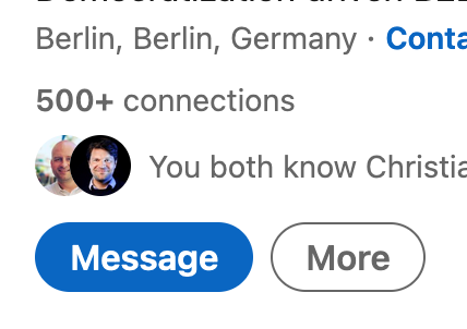
Here's screenshot from LinkedIn where they refer to a user's location
as
Berlin, Berlin, Germany
Solving the address formatting problem
In each geocoding result you will find a section of information called the
components
Here, for example, are the components we return for a request to
reverse geocode the coordinates
52.5432379, 13.4142133
(the OpenCage office in Berlin, Germany).
"components" : {
  "ISO_3166-1_alpha-2" : "DE",
  "ISO_3166-1_alpha-3" : "DEU",
  "ISO_3166-2" : [
    "DE-BE"
  ],
  "_category" : "building",
  "_normalized_city" : "Berlin",
  "_type" : "building",
  "city" : "Berlin",
  "city_district" : "Pankow",
  "continent" : "Europe",
  "country" : "Germany",
  "country_code" : "de",
  "house_number" : "78/79",
  "neighbourhood" : "Bremer H\u00f6he",
  "office" : "Office Club",
  "political_union" : "European Union",
  "postcode" : "10437",
  "road" : "Pappelallee",
  "state" : "Berlin",
  "state_code" : "BE",
  "suburb" : "Prenzlauer Berg"
},
"formatted": "Office Club, Pappelallee 78/79, 10437 Berlin, Germany",
console.log(result.formatted);
// "Office Club, Pappelallee 78/79, 10437 Berlin, Germany"
_type
(in this case "Office Club") is included in the
formatted
value. This can be turned off via the
optional
address_only
parameter
in which case the
formatted
portion of the response is simply:
"formatted": "Pappelallee 78/79, 10437 Berlin, Germany",
components
object directly rather than trying to parse formatted back apart.
formatted
is meant for display,
components
is meant for programmatic use.
More examples
You might think this is a relatively minor problem, but it becomes much
more complex when you are building a service managing addresses in
multiple countries. Have a look at these addresses
'au': '223 William Street, Melbourne VIC 3000, Australia'
'de': 'Rosenthaler Straße 1, 10119 Berlin, Germany'
'es': 'Carrer de Calatrava, 68, 08017 Barcelona, Spain'
'gb': '115 New Cavendish Street, London W1T 5DU, United Kingdom'
'it': 'Via Canosa 92, 76121 Barletta BT, Italy'
'za': '3 Upper Alma Road, Rosebank, Cape Town, 7700, South Africa'
In six different countries we have six different formats! Painful.
Shorter, please
There may be times space for displaying a location is limited. We provide
an optional parameter
abbrv
when set we attempt to abbreviate the formatted string. For example
"United States of America" becomes "USA".
The templates we use for the abbreviations can also be found in the
address-formatting repository on GitHub.
For more details see the
API documentation of the
abbrv
parameter
.
Our open source address templating project
The rules we use to do the formatting from the data available to us in the
components
are all
open sourced in our
address-formatting
project on GitHub,
along with hundreds of tests. The templates are
independent of any programming language. We maintain
Geo::Address::Formatter,
a parser in Perl, but parsers have now also been written in many other
languages as well. The templates are actively maintained and we welcome
all contributions, especially tests for edge cases where we can improve.
Further reading
Happy geocoding!
2,500 geocoding API requests/day - No credit card required